Somerville Tree Health

By Helen Bailey, Scott Gilman, Sofia Reinach, & Olivia Brode-Roger

The data say that Somerville’s many trees face several vulnerabilities, including their health and proximity to unrepaired natural gas leaks that can suffocate their roots. We want to tell this story because we all benefit from trees on our streets and in our parks, but we often take them for granted and ignore the threats they face. Our audience is residents of Somerville. Our goals are to educate them on the condition of trees in their neighborhood and prompt them to take action to protect Somerville’s urban canopy.

We tell this story using an interactive website that local advocacy groups could share on social media. First, users select their neighborhood from a map of Somerville, and then a series of three maps presents the canopy size/area of shade provided, tree condition, and hazard from unrepaired gas leaks. This interaction and our use of the maps as a portrait of each neighborhood’s trees allows the user to find themselves more easily in the data and connect the maps to their lived experience with trees in the neighborhood. After looking at the maps, users are then asked which aspect of tree health they most care about, both to collect data for the advocacy group to help tailor their outreach and to show an appropriate call to action (for example, call a number to request a new tree, or contact the Public Utilities Commission to pressure the utilities to repair minor leaks).

We originally were looking at the gas leak data by itself, but found it difficult to tell a meaningful story on its own. So, we then looked at which gas leaks were threatening trees as a hook to get people to care about gas leaks, and decided to center our narrative on other measures of tree health

See Like a Bee

Haley Meisenholder, Jay Dev, Marc Gomez, Maddie Pelz

The data say that bee populations have been dramatically decreasing in most of the US over time. Our audience is a visitor to the USDA websitee who wants to learn more about bees and find out what they can do to help them recover from their population losses. Our goals are to inform people who might not think of bees as anything special about how much bees contribute to the success of agriculture across the country, and how threatened they are as a species. It is also our goal to then link people using this platform up with resources for them to explore different plants they can plant in their own garden to help support bees, how they can support legislation to protect bees in their state, and where they can find local honey to purchase.

Our data story takes the form of an interactive website. The viewer starts on a page with an overview of the bee populations in each state using data on honey producing colonies from the USDA. They then identify what state they are from to narrow in on the data and explore the information most relevant to them. Once the participant enters where they live, you can explore the health of the bees in your state by learning the extent to which bees were lost between 2001 and 2011, and then see most current numbers for 2017.

After learning on the first page that bees are crucial to agriculture, on the second page they are able to see the general changes in the bee populations in their state (most decreasing dramatically). After viewing this information, participants can then activate ‘bee vision, ’ created from data from the National Land Cover Database (2011). ‘Bee Vision’ shows vegetation land lost between 2001 and 2011. This map links land use to bee health, demonstrating how these changes to agriculture threaten their survival.

After exploring ‘bee vision,’ the next page then acts as a way to inform people about what they can do to make a difference. Rather than just a general call to action, this page provides an array of information that people can use to take specific steps towards action. In addition to information about the three ways to move forward that were mentioned previously, there are links to organizations or contact information that allow for immediate action to be taken.

Vitamin Bee

Vitamin Bee

By Margaret Sands, Kunyi Li, Yihang Sui, and Rikhav Shah

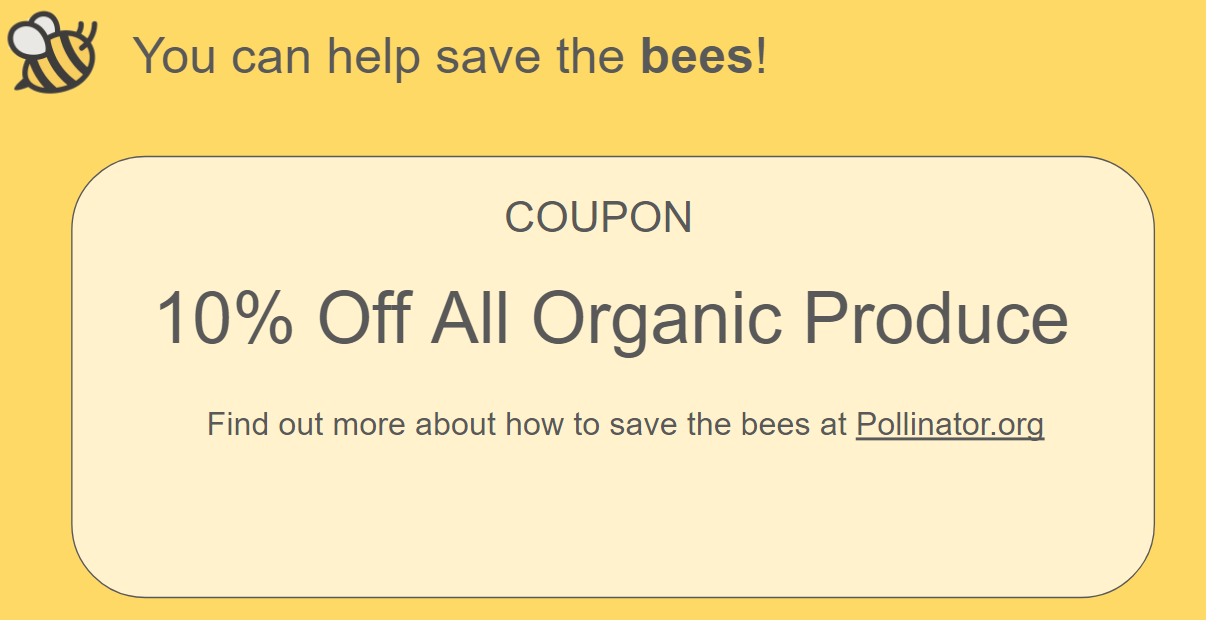
The data say that bee colonies are dying in large numbers across the United States due to various health stressors such as mites and pesticides. We want to tell this story because bees influence many parts of our daily lives without our knowledge. Many fruits and other crops rely on bees and other pollinators to create a larger and better quality harvest. However, most consumers of fruit do not consider the relationship. We want to inform grocery shoppers at supermarkets about the conditions of bee colonies in states that produce their favorite fruits and how widespread the problem is across the entire country, and urge them to take action to protect bees. Our audience is shoppers at supermarkets, possibly organic supermarkets like Whole Foods where customers would be more inclined to care about the environment. Our visualization is in the form of an interactive activity that would be displayed on a touch screen monitor or tablet along with a facilitator to guide the user through the experience. We incentivize grocery shoppers to participate in this activity by offering them a coupon on organic produce if they complete the activity.

The activity starts by prompting the user to pick their favorites in a list of fruits. The list of fruit is purposefully selected in that they are all fruits that rely on bee pollination. Then the user is presented with facts regarding the fruit that are also related to bees so they become aware that their favorite fruit is heavily tied to bees. For our example, the user has selected strawberries.

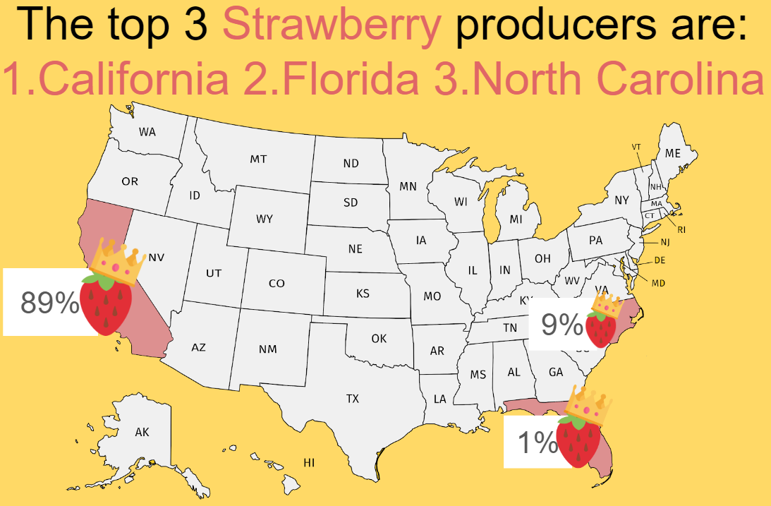
Next, the user is asked to guess which state they think produces the largest amount of their favorite fruit by dragging the fruit icon over a state. Once they’ve selected a state, we will reveal the 3 states that are the top producers of that fruit so the user can see if they guessed correctly.

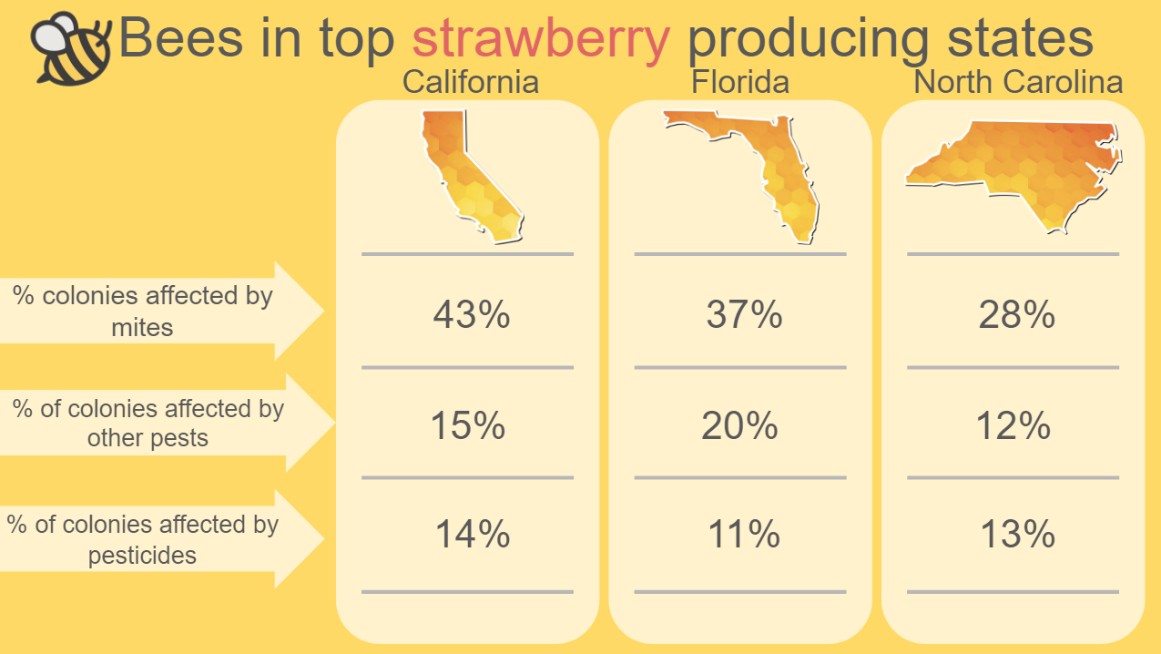
As we want to inform the user about bees in these states, we then present a side by side comparison of bee conditions in those three states. Stats included are bee population, annual percentage of bee colonies lost, and percentage of colonies affected by various health stressors.

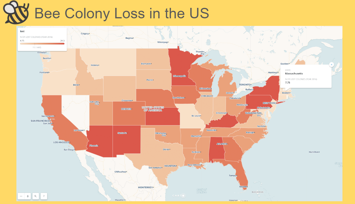
At this point, the user has only seen the problem of disappearing bees in three specific states, but we also want them to know that this problem is nationwide. To do this, we show them a map of bee colony loss in all the states across the country where they can select different states to see the percentage of annual bee colony loss in the selected state.

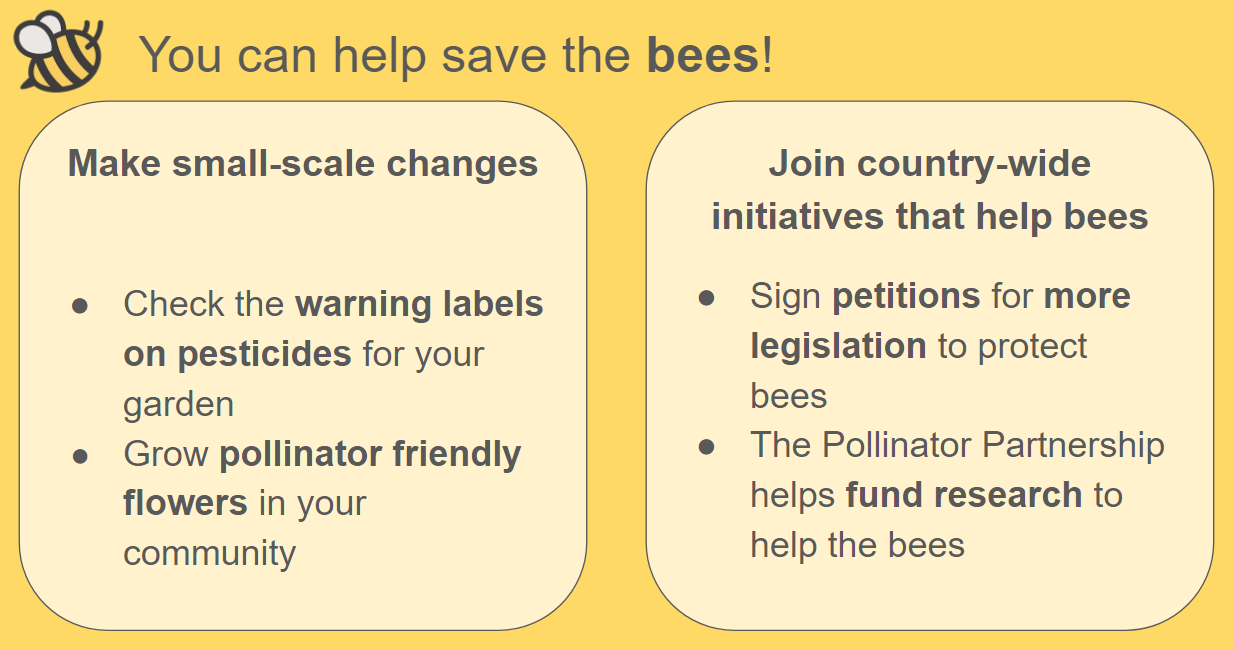
After they’ve seen the problem in the context of states and the entire US, we invite the user to create change. These invitations range from actions they can take in their own yard, like changing their pesticide of choice to a bee-friendly brand, to actions they can take in their own community, like helping plant a community garden, to actions they can take that can help bees across the country, like donating to research funds, calling their legislature, signing petitions, or even volunteering time to log information about local colonies for studies.

We think this will be an effective way to encourage shoppers to play a more active role in helping the bees. By having them pick their favorite fruit, the shopper is predisposed to care more about that fruit than a preselected one. Looking at individual states and how they compare emphasizes the problem of bee loss across the different states. Allowing the user to explore different the values across the United States outside of the spoon-fed data gives the experience a more personal feeling. If we had more time to iterate, we would focus on adding more data to the US map. Currently, the map focuses on only colony loss data. However, it could be augmented to add lower-level colony data or data relating to more fruits than what the user has currently selected.


Sources:

USDA data on fruit production
Pollinators.org
Bee pollination improves crop quality, shelf life and commercial value

Leaksweeper

Mitchell Myers, Caroline Liu, Arturo Chavez, Alicia Ouyang

Boston’s natural gas pipes are prone to corrosion and leaks due to their age, so we want to raise awareness in our local community. We looked at the natural gas dataset, and decided to focus on “lost” leaks and “found leaks. “Found” leaks are natural gas leaks that have been are recorded by the natural gas utilities through the years as unrepaired. In contrast, “lost leaks” are leaks that were recorded as “unrepaired”, but disappeared in following years from the records without being recorded as “repaired”. We want to tell the story of “lost leaks” because natural gas leaks are often colorless, yet have major consequences by contributing to greenhouse gases, creating fire hazards, and increases financial costs on residents. Our goal in creating our combined game of minesweeper and Boston/Cambridge maps is to teach local residents about the “lost leaks” problem, and lobby for stricter accountability measures on utility companies.

Our audience would encounter Leaksweeper through social media sharing, by the advocacy group or petition signers. We choose to use small maps around specific districts and neighborhoods since people know the areas around where they live or where they work. We encourage interaction through the minesweeper interface overlay, where the mines represent the natural gas leaks. Since we have different types of leaks, flags already mark the “found” leaks when the game begins. The goal of the player is to flag all the “lost” leaks while avoiding clicking on them. A consequence of natural gas leaks are explosions, and we wanted the audience to explore the map, so we believed representing the leaks by exploding mines in a game of minesweeper is an effective way to bring our message across. At the end of the game, we urge the player to take action by visiting petition website, https://bostoncan.org/ma-gas-leaks-and-pipelines/ , and share the game.